by Lucky Lucan » Fri Jul 12, 2019 3:55 pm
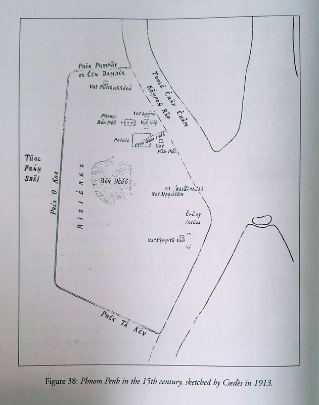
The canals were first built in the 15th century when the capital was established by King Ponhea Yat. The first palace was built a little to the SE of Wat Phnom, in the area now covered by the 106/108 st park. A large amount of soil was used to fill the ground around Wat Phnom and the palace, it was taken from the area where Psah Thmey now stands, which turned that area into a swamp/lake called Boeung Decho.
There was a canal built from the river to the palace, to a small reservoir supply water, it was covered over with stones to make it underground. The canal in the south was called Prek Ta Kev/ Keo (Prek is a canal, Ta Kev/ Keo means stream. Part of this still existed till it was filled in building Independence Monument, and it was later connected to the "Sacred Lake" where the park at Wat Botum is now. The canal to the west was called Prek O' Kor ( Silkweed Stream) - a bit west of present day Monivong, and to the north was Prek Pum Peay, which was also called Prek Chan Dam Dek (canal where Chinese beat metal) because there were Chinese blacksmiths who made swords there. This was just south of where the Chruoy Changva Bridge is now. So the French basically just improved/ expanded some of the canals that already existed.
Picture from "Modern Khmer Cities" by Vann Molyvann.
The canals were first built in the 15th century when the capital was established by King Ponhea Yat. The first palace was built a little to the SE of Wat Phnom, in the area now covered by the 106/108 st park. A large amount of soil was used to fill the ground around Wat Phnom and the palace, it was taken from the area where Psah Thmey now stands, which turned that area into a swamp/lake called Boeung Decho.
There was a canal built from the river to the palace, to a small reservoir supply water, it was covered over with stones to make it underground. The canal in the south was called Prek Ta Kev/ Keo (Prek is a canal, Ta Kev/ Keo means stream. Part of this still existed till it was filled in building Independence Monument, and it was later connected to the "Sacred Lake" where the park at Wat Botum is now. The canal to the west was called Prek O' Kor ( Silkweed Stream) - a bit west of present day Monivong, and to the north was Prek Pum Peay, which was also called Prek Chan Dam Dek (canal where Chinese beat metal) because there were Chinese blacksmiths who made swords there. This was just south of where the Chruoy Changva Bridge is now. So the French basically just improved/ expanded some of the canals that already existed.
[url=https://postimg.cc/5XPWGCX5][img]https://i.postimg.cc/6QK68VwP/15th-c.jpg[/img][/url]
Picture from "Modern Khmer Cities" by Vann Molyvann.
