Found this while searching for Batjong, given as an alternative name for the Harry Potter town. It's called UNIVERSAL GEOGRAPHY, a description of all the Parts of the World on a New Plan", pub. 1834. It has some good stuff:
* The Mekong has 3 mouths, the Saigon River, the Bassac, and "the Inconvenient". "It is said that great lake or inland sea is connected with these mouths." Love the "it is said".
*"Leuvok (the capital) consists of a single street with one large temple." "A short way from the capital are to be seen the ruins of an ancient city, the architecture of which shows something of the European style..."
*Batjong is on the river "north of Cambodia," meaning Lovek, the capital. Srey Santhor is on the Mekong not far from Phnom Penh, but Lovek is on the Tonle Sap River, so the direction is right but the river seems wrong, as he seems to be referring to a place on the Tonle Sap river. But then he says that after Batjong comes "Sumbapoor", where there's a "high priest" who "assumes the title of raja and exacts a toll from passengers." This sounds like the abbot of the monastery Wat Sambok in Kratie, who was given the duty of collecting tolls on the Mekong in the very early 17th century.
*It mentions Ponthiamas, an "independent kingdom" founded in 1705 by a Chinese merchant. This must be HaTien, now on the Cambodia-Vietnam border, founded by refugees from the final collapse of the Ming, but a bit earlier than that. It was a famous trading port and nest of pirates in the late 18th century, outside anyone's control.
This is the link: https://books.google.com.au/books?id=YX ... 22&f=false
Map Collection from the early 1600s to 1891
Langor and Carol are both mentioned in this book from 1701:Lucky Lucan wrote:I noticed there weren't too many familiar names on the older maps. There are some weird ones, like "Striponob" on the 1847 map. It looks like the British surveyors decided to call someplace in the vicinty of Langor "The Mullet". Langor seems fairly consistent on a few maps though, maybe it's an old name for Koh Kong or Trat or somewhere around there?LexusSchmexus wrote:I wonder what Langor referred to. Whether it was an actual location or not.
pages 70-71
https://books.google.com.kh/books?id=5m ... &q&f=false


Is that "Isle de Mofo" or "Isle de Mojo" in the middle there? Either way very interesting -jackrossi wrote:

Meum est propositum in taberna mori,
ut sint Guinness proxima morientis ori.
tunc cantabunt letius angelorum chori:
"Sit Deus propitius huic potatori."
ut sint Guinness proxima morientis ori.
tunc cantabunt letius angelorum chori:
"Sit Deus propitius huic potatori."

It's from 1618 the original is on auction starting at about 250$

-
Barang_doa_slae

- cannonballer
- Reactions: 37
- Posts: 2434
- Joined: Tue Dec 24, 2013 9:44 am
That is a very low starting price. It is less than a century older than the earliest maps on the market and I would expect it to easily reach 3k probably 5, way more if of any historical importance.jackrossi wrote:It's from 1618 the original is on auction starting at about 250$
If I remember correctly I paid around 300€ for that 1802 map I posted on an earlier page of this thread. It was most probably taken from an atlas printed in the hundreds. That is line with some european, african and american maps that I sold in auctions. Some of the oldest including a rare but b&w17th century map of hollands french provinces went for less than an unexpected early 20th century english map. It is of course all about rarity.
It's quite small, 12.5*8.5cm since it's a copper engraved miniature map that is why it is cheaper.
But if you want it for your collection I can get for you.
But if you want it for your collection I can get for you.
-
Lucky Lucan

- K440 Knight Captain
- Reactions: 761
- Posts: 22525
- Joined: Fri Mar 04, 2011 12:24 pm
- Location: The Pearl of the Orient
There's no way that map is anything like that old considering how white the paper is and how crisp the lines and colors are. It looks great, but it's repro.
Romantic Cambodia is dead and gone. It's with McKinley in the grave.
You think so? The seller seems reputable selling maps for many years. They even sell on eBay now with a ton of feedback selling only maps and old prints. if it's replica you should notify them.
I give you the link:
http://vi.raptor.ebaydesc.com/ws/eBayIS ... spheader=1
I give you the link:
http://vi.raptor.ebaydesc.com/ws/eBayIS ... spheader=1
-
Kampot Homesteader
- I live above an internet cafe
- Reactions: 0
- Posts: 201
- Joined: Tue Jul 26, 2016 8:28 am
these are wonderful.
i want to print them all and wallpaper the den.
i want to print them all and wallpaper the den.
-
Lucky Lucan
- K440 Knight Captain
- Reactions: 761
- Posts: 22525
- Joined: Fri Mar 04, 2011 12:24 pm
- Location: The Pearl of the Orient
I was just guessing, it would be impossible to tell from a photo, and maybe they've bumped up the colors for the ad.jackrossi wrote:You think so?
Romantic Cambodia is dead and gone. It's with McKinley in the grave.

Bumping this as I've been tracking down every map featuring Cambodia <1900 and following some rabbit holes..
Sambokchut village, which appears in the above map north of Sambok is referenced in this book from 1771. Using Longvek as the centre point, it references to the north a "city "Columpé" - modern Kampi? It's just a short drive north of Sambok, and to the south Ponomping and the first reference I've seen to "le temple de Balbanon". Ponomping = Phnom Penh, obviously, but not sure where the temple Balbanon refers to.
Au nord d Eauweck est la ville de Columpé & la bourgade de Sombochut au midi elle a la ville de Ponomping & le temple de Balbanon.
Parmi les six ports qui sont sur ses côtes on ne connait plus gueres que ceux de Langor de Cacol ou Karol & Pontameas ou Ponthiamas ou Cancar ce dernier était fort fréquenté des étrangers mais les Siamois le ravagerent en 1717 & le commerce s en éloigna dès lors
To the north of Eauweck is the city of Columpé & the village of Sombochut to the south it has the city of Ponomping & the temple of Balbanon
Among the six ports that are on its shores we do not know any more guards than those of Langor de Cacol or Karol & Pontameas or Ponthiamas or Cancar the latter was popular with foreigners but the Siamese ravaged in 1717 & the trade was away from then
--
Which leads to Pontameas / Ponthiamas / Pontiamo
Ce lieu & les campagnes voisines languissaient abandonnés: un Chinois les parcourut vit ce qu elles pouvaient être & forma le projet de les cultiver Kiang tse (était son nom) s'instruisit des arts propres à son dessein se ménagea la protection des princes voisins & bientôt on vit naitre sous ses mains une petite ville entourée de remparts & de fossés défendue par de l artillerie.
Les colons qu il avait rassemblé requrent des terres à cultiver avec les instrumens nécessaires ils reçurent le tout sans être soumis à des redevances onéreuses; les loix du fondateur de ce petit Etat se réduisirent à des mœurs simples, à des coutumes qui inspiraient la frugalité, l'amour du travail & la bonne foi: bientôt on a vu succèder de riches moissons à d inutiles forêts, à des marais infeéts, & le port a été fréquenté par les nations voisines, qui y sont venues chercher les provisions qui leur manquaient.
This place and the neighboring countryside languished abandoned: a Chinese ran through them saw what they could be & formed the project to cultivate them, Kiang tse (was his name) learned the arts proper to his design spared the protection of neighboring princes & Soon, a small town surrounded by ramparts and ditches defended by artillery was born under his hands.
The colonists whom he had collected required land to be cultivated with the necessary instruments; they received all without being subjected to expensive royalties; the laws of the founder of this little state were reduced to simple customs, to customs which inspired frugality, the love of work, and good faith: soon we saw succeeding rich harvests to useless forests, to infertile marshes The port was frequented by the neighboring nations, who came there to fetch the provisions they needed.
--
The book suggests Banteay Meas was established from scratch by Kiang Tse, but Ponteamas is also suggested to be the ancient port of Cattigara, which is possibly the farthest port reached by far earlier explorers, and further that ancient Cambodia was in fact what was previously thought to be China / Sinae:
From "Mr Caverhill proves the ancient Cattigara to be the same with the modern Ponteamass (Banteaymeas), The Monthly Review, Or, Literary Journal, Volume 40, 1769, p.98.":

Cattigara is thought to be the Roman name for the major port of the Magnus Sinus - the Ptolemic name for the Gulf of Thailand. The Roman Cattigara was Funan era Óc Eo (o'keo / glass canal), which is modern day Thoại Sơn District in Vietnam. There is a man made canal running from Angkor Borei south to Óc Eo that is believed to date from the Funan era.

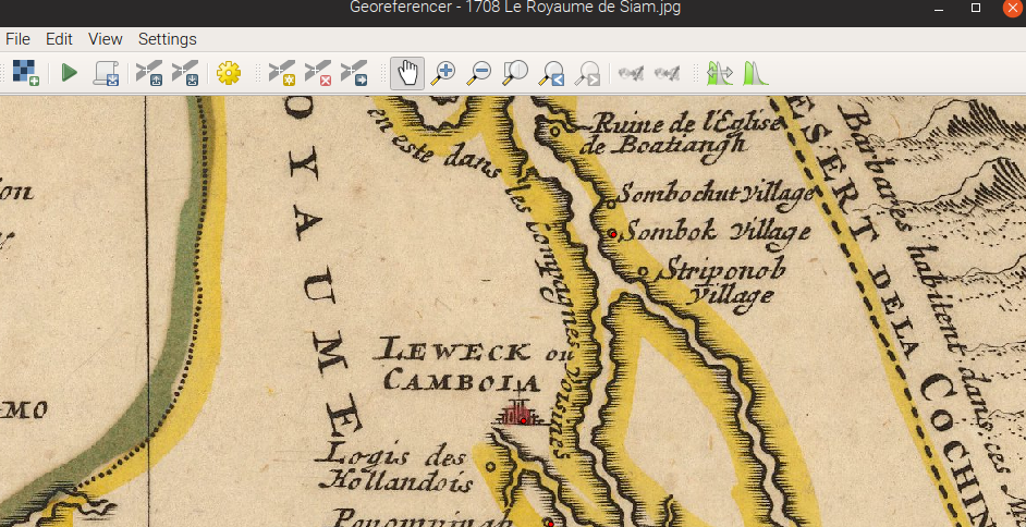
This 1708 map of the Royaume du Siam features "Sambok village" north of Striponob, so is Sambok is the same as present day Sambok, then it's likely that Striponob is Kratie or Srey Santor.PJC wrote: *Batjong is on the river "north of Cambodia," meaning Lovek, the capital. Srey Santhor is on the Mekong not far from Phnom Penh, but Lovek is on the Tonle Sap River, so the direction is right but the river seems wrong, as he seems to be referring to a place on the Tonle Sap river. But then he says that after Batjong comes "Sumbapoor", where there's a "high priest" who "assumes the title of raja and exacts a toll from passengers." This sounds like the abbot of the monastery Wat Sambok in Kratie, who was given the duty of collecting tolls on the Mekong in the very early 17th century.
Sambokchut village, which appears in the above map north of Sambok is referenced in this book from 1771. Using Longvek as the centre point, it references to the north a "city "Columpé" - modern Kampi? It's just a short drive north of Sambok, and to the south Ponomping and the first reference I've seen to "le temple de Balbanon". Ponomping = Phnom Penh, obviously, but not sure where the temple Balbanon refers to.
Au nord d Eauweck est la ville de Columpé & la bourgade de Sombochut au midi elle a la ville de Ponomping & le temple de Balbanon.
Parmi les six ports qui sont sur ses côtes on ne connait plus gueres que ceux de Langor de Cacol ou Karol & Pontameas ou Ponthiamas ou Cancar ce dernier était fort fréquenté des étrangers mais les Siamois le ravagerent en 1717 & le commerce s en éloigna dès lors
To the north of Eauweck is the city of Columpé & the village of Sombochut to the south it has the city of Ponomping & the temple of Balbanon
Among the six ports that are on its shores we do not know any more guards than those of Langor de Cacol or Karol & Pontameas or Ponthiamas or Cancar the latter was popular with foreigners but the Siamese ravaged in 1717 & the trade was away from then
--
Which leads to Pontameas / Ponthiamas / Pontiamo
From what I've found (link below), Pontameas / Ponthiamas / Pontiamo = Banteay Meas. Present day, it's the district directly north of Ha Tien. Banteay Meas ~ "Golden fortress". The same book describes the Chinese merchant ruler of this autonomous area: Kiang Tse:PJC wrote: *It mentions Ponthiamas, an "independent kingdom" founded in 1705 by a Chinese merchant. This must be HaTien, now on the Cambodia-Vietnam border, founded by refugees from the final collapse of the Ming, but a bit earlier than that. It was a famous trading port and nest of pirates in the late 18th century, outside anyone's control.
Ce lieu & les campagnes voisines languissaient abandonnés: un Chinois les parcourut vit ce qu elles pouvaient être & forma le projet de les cultiver Kiang tse (était son nom) s'instruisit des arts propres à son dessein se ménagea la protection des princes voisins & bientôt on vit naitre sous ses mains une petite ville entourée de remparts & de fossés défendue par de l artillerie.
Les colons qu il avait rassemblé requrent des terres à cultiver avec les instrumens nécessaires ils reçurent le tout sans être soumis à des redevances onéreuses; les loix du fondateur de ce petit Etat se réduisirent à des mœurs simples, à des coutumes qui inspiraient la frugalité, l'amour du travail & la bonne foi: bientôt on a vu succèder de riches moissons à d inutiles forêts, à des marais infeéts, & le port a été fréquenté par les nations voisines, qui y sont venues chercher les provisions qui leur manquaient.
This place and the neighboring countryside languished abandoned: a Chinese ran through them saw what they could be & formed the project to cultivate them, Kiang tse (was his name) learned the arts proper to his design spared the protection of neighboring princes & Soon, a small town surrounded by ramparts and ditches defended by artillery was born under his hands.
The colonists whom he had collected required land to be cultivated with the necessary instruments; they received all without being subjected to expensive royalties; the laws of the founder of this little state were reduced to simple customs, to customs which inspired frugality, the love of work, and good faith: soon we saw succeeding rich harvests to useless forests, to infertile marshes The port was frequented by the neighboring nations, who came there to fetch the provisions they needed.
--
The book suggests Banteay Meas was established from scratch by Kiang Tse, but Ponteamas is also suggested to be the ancient port of Cattigara, which is possibly the farthest port reached by far earlier explorers, and further that ancient Cambodia was in fact what was previously thought to be China / Sinae:
From "Mr Caverhill proves the ancient Cattigara to be the same with the modern Ponteamass (Banteaymeas), The Monthly Review, Or, Literary Journal, Volume 40, 1769, p.98.":
Cattigara is thought to be the Roman name for the major port of the Magnus Sinus - the Ptolemic name for the Gulf of Thailand. The Roman Cattigara was Funan era Óc Eo (o'keo / glass canal), which is modern day Thoại Sơn District in Vietnam. There is a man made canal running from Angkor Borei south to Óc Eo that is believed to date from the Funan era.
-
- Similar Topics
- Replies
- Views
- Last post
-
- 0 Replies
- 2906 Views
-
Last post by Londo
Mon Jul 17, 2023 1:57 pm