GPS Coordinates 1st Jan Dam Worksite?
GPS Coordinates 1st Jan Dam Worksite?
My google skills are failing me. I cannot find GPS coordinates for the 1st Jan Dam. I know it's still there because there are youtube videos of kids playing in it....it's in K Thom, but where? Thanks.
First of all, it's not 1st of January, but 7th of January (Victory over Genocide Day) Dam, or Bridge. And it's not in Kampong Thom but on the border of Phnom Penh and Kandal. You've probably crossed it many times, as it's a bridge in National Road 3:

It does seem a tricky one.
The closest I can find is from here:
https://cambodiatribunal.org/2015/05/19 ... tion-site/
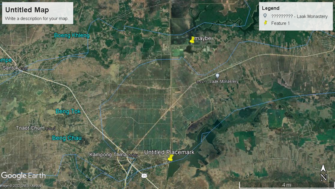
This suggests at the south of Prasat Balangk commune, and makes reference to a village where workers would stay within 3km of the dam nearby: Prei Snhea village. trouble is, I can't find that village anywhere on a modern map of BalangK - and no such Wikipedia entry on the list of villages. Need a Cambodian to go through the Khmer docs, maybe it was renamed.
That said, it clearly was there to block the Stoeung Chinit river, and was close to another dam, 6 Makara Dam. Looking at Google Maps I'm thinking as it was then there to block the river & to create channels for irrigation, the location is the west end of that river; around about here where it ceases to be a river & is clearly turned into a canal thereafter. But could be wrong. Damn it, LL is going to be here in a minute and give you the lat/long isn't he ...
https://www.google.com/maps/place/Tnaot ... 05.0630478
The closest I can find is from here:
https://cambodiatribunal.org/2015/05/19 ... tion-site/
This suggests at the south of Prasat Balangk commune, and makes reference to a village where workers would stay within 3km of the dam nearby: Prei Snhea village. trouble is, I can't find that village anywhere on a modern map of BalangK - and no such Wikipedia entry on the list of villages. Need a Cambodian to go through the Khmer docs, maybe it was renamed.
That said, it clearly was there to block the Stoeung Chinit river, and was close to another dam, 6 Makara Dam. Looking at Google Maps I'm thinking as it was then there to block the river & to create channels for irrigation, the location is the west end of that river; around about here where it ceases to be a river & is clearly turned into a canal thereafter. But could be wrong. Damn it, LL is going to be here in a minute and give you the lat/long isn't he ...
https://www.google.com/maps/place/Tnaot ... 05.0630478
Meum est propositum in taberna mori,
ut sint Guinness proxima morientis ori.
tunc cantabunt letius angelorum chori:
"Sit Deus propitius huic potatori."
ut sint Guinness proxima morientis ori.
tunc cantabunt letius angelorum chori:
"Sit Deus propitius huic potatori."
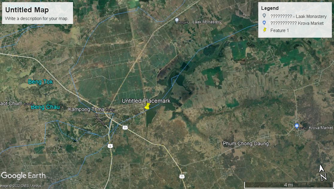
Oh hold on, there is a "Stoeung Chinit Tourism Site" ... that's it, the rebel base is there...
https://www.google.com/maps/place/Stung ... 05.1474428
But the tribunal article does say the other dam is 6km away from the 6 Makara Dam, so I think maybe the real site is the west end of the river as I mentioned before. Certainly if you got to the "Tourism" site, I'm sure a local could point you the last 6km accurately.
Meum est propositum in taberna mori,
ut sint Guinness proxima morientis ori.
tunc cantabunt letius angelorum chori:
"Sit Deus propitius huic potatori."
ut sint Guinness proxima morientis ori.
tunc cantabunt letius angelorum chori:
"Sit Deus propitius huic potatori."
-
Lucky Lucan
- K440 Knight Captain
- Reactions: 761
- Posts: 22525
- Joined: Fri Mar 04, 2011 12:24 pm
- Location: The Pearl of the Orient
It's not that dam, it's one built in the DK era. They wouldn't name a dam 7th January. It's possibly called 1st January after the final offensive on Phnom Penh which was launched on 1st January 1975. It's most likely the one Spigzy posted in the tribunal report.frigidaire wrote: ↑Mon Mar 14, 2022 11:20 amFirst of all, it's not 1st of January, but 7th of January (Victory over Genocide Day) Dam, or Bridge. And it's not in Kampong Thom but on the border of Phnom Penh and Kandal. You've probably crossed it many times, as it's a bridge in National Road 3:
Romantic Cambodia is dead and gone. It's with McKinley in the grave.
Oops, my bad, indeed it's what Spigzy said, the "Stoeung Chinit Tourism Site".
Yes, this is the right one. You can ignore my other reply to the group. If I can get myself here then I'll have my local fried who's driving me help me find the site 6km away...more research ahead...Thanks!!
Spigzy wrote: ↑Mon Mar 14, 2022 12:04 pmOh hold on, there is a "Stoeung Chinit Tourism Site" ... that's it, the rebel base is there...
https://www.google.com/maps/place/Stung ... 05.1474428
But the tribunal article does say the other dam is 6km away from the 6 Makara Dam, so I think maybe the real site is the west end of the river as I mentioned before. Certainly if you got to the "Tourism" site, I'm sure a local could point you the last 6km accurately.
1
1

About 6 K North. Good canal road.